Showing posts with label environment. Show all posts

Monday, October 25, 2010

Walking in the Devon woods

All of Katharine’s cousins like to hike, so our visits to England always include explorations of their local countryside. Most of our relatives live in central England, but one cousin had moved to Devon since we’d last visited, and we were eager to be introduced to this part of SW England.

PA240332
Eric taking photos from a rock overlooking the valley of the
River Teign along the path to Fingle Bridge from Castle Drogo.
Yet another sunny day threatened to dispel the clichéd view of damp English weather as we drove to nearby Drogo Castle. Now a National Trust site, the castle was completed for food retailing magnate Julius Drewe in 1931. The castle is located on a prominent bluff, and the site includes our destination for the day: a network of walking trails leading along the nearby River Teign.

Not surprisingly on such a fine autumn day, we were not alone as we walked along the edge of the steep valley to descend to Fingle Bridge.

Most walkers stopped at the old stone pub at the bridge, but we continued on along the river for a few kilometres. By the time we returned, the crowds had lessened—but we were only moments from their last call for lunch. The pub lunch and local cider on the outdoor patio was a welcome break before heading back along the river valley trails and the climb back up to the castle.

IMG_0101
These two little girls were dropping twigs off the upstream side, then rushing to
see them float by on the downstream side. Fingle Bridge, near Exeter in Devon.
This area seems so pristine and pastoral, yet a closer look reveals evidence of past industry. The very narrow Fingle bridge is made of rough-hewn stone, and the pub was once a mill; piles of rubble along the trail were probably mine tailings; and old foundations are visible amongst the trees.

IMG_0122
Today the River Teign water looks clean enough to drink, but likely only due to very concerted efforts to restore the local environment.

Is all the effort worthwhile? I suspect the many people we saw enjoying it on this sunny autumn afternoon would not want it any other way.

Saturday, October 16, 2010

The highlands are actually quite low

In my mind, the Scottish “highlands” have always conjured up visions of misty crags covered with heather and bracken. We have visited Scotland several times, and have always managed to include some hiking in the hills.

But our stay at a comfortable remote chalet on the NW coast in October was a real eye-opener to the nature of the highlands. The cottage is on the sea, yet within 3 minutes we could be climbing amidst the heather; within 10 minutes we could be out of view of any buildings and roads.

PA090366
Stac Pollaigh. We climbed this in 1981, but although the weather at the time we passed looked clear, it was only a brief spell of late afternoon sunshine.
In this part of Scotland, trees only grow in sheltered areas, so the treeless “highlands” start just a few metres above the sea level. The hills are not particularly high either: there are only 283 peaks over 914m (a “munro” is a peak of >3,000 feet) within Scotland, and although nearby Stac Pollaidh is an impressive-looking peak, it is “only” 612m high.

IMG_0333
Peering over the ridge to avoid startling stags.
October is rutting season for deer, and the bellows of stags echoed in the hills the night we arrived. We were with my cousin and her husband, and Wayne was keen to take us up into the hills to stalk stags. Just as well he was guiding us: it was clear that “stalking” was necessary, as these animals are very attentive and were easily spooked.

After a couple of hours happily wandering over the hills, we had seen several stags at a distance —young males or ones that were unable to attract a harem of hinds. But then Wayne peered over a ridge and held up his hand to caution us to stop. “Shh... here’s the main herd!”

We got down on our tummies and lifted our heads to look over the rocky ridge. A large stag was looking at us from the opposite ridge—as more than 20 of his hinds were nervously moving further up the hill.

PA130029
A stag and his hinds.
The life of a stag is not easy. There is only room for one top animal, and there are always contenders for the position lurking around the edges trying to lure hinds away. Eventually, the dominant stag is defeated—or shot. We felt privileged to have the opportunity to see these animals in their environment.

Friday, September 3, 2010

Best intentions

“So where are you two now? Are you ever coming home?”

Uh oh… That’s the problem with starting a blog and not keeping at it! In Australia we had all the best intentions to catch up, and post frequently—but the days rolled on with other things to do…

Rain? No worries! Wednesday walks with the Portland Field Nats are on rain or shine.As well, we discovered that some topics just don’t lend themselves to a blog—at least not the sort of blog we’d started.

We have been meeting new friends, and spending time with people socially in ways that were quite different than when we were “on the road”.

IMG_9763I have been taking lots of pictures, and we have both become quite involved in things we find interesting, so we have lots to tell—but in person rather than in the form of a blog.

We have told people that this year is one of taking stock, and trying to gain a perspective about how to retool for what we do next.

I suspect that blogging may still be part of do—but I now know that it won’t be quite what I’d expected when we left home.

Tuesday, August 3, 2010

Whales in the waters

Towns with decent harbours along the southern coast of Australia boomed during the heyday of the whaling era. Whales come north from Antarctic waters to calve and feed as nutrient-rich currents push up against the continental shelf.
Fortunately, whales are no longer killed, and the industry has vanished. Today, whales are a big draw for tourism, and the many cliffs along these shores provide excellent vantage points to observe these giants.
Logan’s Beach in nearby Warrnambool is a popular whale watching destination, and when we visited there recently, we were rewarded with the sight of a Southern Right whale basking in the swells just beyond a group of keen surfers.
IMG_9804
Southern Right whale off Logan's beach, Warrnambool. Note the surfers in the foreground.
The lookout point has excellent interpretive signage, and explains that the “Right” whale was so named because it was the “right” one to kill: it was slow, had plenty of oil and floated when dead.
Not so “right” for the whales though: an estimated population of 60,000 when whaling began in earnest on these coasts in 1806 had declined to only 300 animals by the early 1920s—and of those, only 60 were female.
Southern Right whales were granted protection in 1935, and since then the population has risen slowly to an estimated 1,200 whales in Australian waters.
Further west along the coast, Portland was a major whaling centre until the industry collapsed in the late 1840s. The tourism centre near the harbour includes an informative museum with a whale skeleton in the lobby. They also have a whale watch email notification service, so we signed up.
Almost daily now we are getting reports of nearby sightings. When we saw that two whales were reported off a beach nearby, we rushed out. Not only were there two very close to the shore (perhaps 40m), but we spied two more a few hundred metres out.
Mature whales can be 18m long and weigh 80-100 tonnes, so seeing them in so close was a real thrill. In both cases, one animal had more prominent crusty “callosities” on the upper jaw, whereas the other was more evenly black. Another local enthusiast there thought we were probably seeing two sets of mother and calf.
IMG_0184
Two Southern Right whales just offshore near the outflow of the Surrey River at Narrawong, VIC.
These two and two others -- probably both sets of mother and calf -- were as close as 40m from the shore. (The image quality is low because this was taken hand-held with the camera's digital zoom.)
We’ll be eagerly watching the whale notifications, and hope to catch a sighting from one of the many cliffs in this area.
The Glenelg Shire Council’s web site provides a history of whale sightings reported in the Portland area.

Wednesday, June 30, 2010

When does wind power just make good sense?

Frequent sightings of wind power projects has prompted lots of discussion as we’ve been exploring Australia. Particularly in areas where there are steady strong winds, it makes me wonder why an industry to provide home wind generators hasn’t taken off.

IMG_9549On the west coast, information panels at the impressive 48-generator Emu Downs project near Cervantes stated that this A$180 million project can provide power for the equivalent of 50,000 homes. Each wind generator was ~A$3.75 million—and likely more since the wind farm can share some expensive common control and distribution systems—but it also means that the wind farm costs work out to ~A$3,600 per home.

What homeowner wouldn’t agree to pay a one-time $3,600 to get energy from the wind forever?

Of course it isn’t quite that simple… Wind farms produce no power when the winds drop below a minimum speed—but consumers want to have power whenever they want it, so a grid connection is still needed.

Electric utilities balance supply and demand over the entire grid, but many (including our own Quebec Hydro) are not eager to let just anyone sell power into their grid. Even when they do agree, utilities can’t buy it at the same rate they sell power because their rate includes a mark-up above their generating costs to cover their significant capital investments.

But what happens as wind generator prices drop and their control systems improve? At some point, won’t it reach a point where—for at least some consumers—installing a wind generator for a home becomes economically too viable to ignore?

Sunday, April 4, 2010

Why can’t Canada get more rapid transit?

Canadian urban dwellers should be envious of SE Asian rapid transit users. Both Bangkok and Singapore have extensive mass rapid transit (MRT) systems very much like Vancouver’s SkyTrain system, with connections to their airports.

Bangkok’s SkyTrain lines connect seamlessly to interurban rail systems and bus lines. Unlike Vancouver’s gateless system, both the Bangkok Transit System and Singapore MRT users go through turnstiles on both entry and exit. Payment is by distance: plastic cards are either loaded with specific fares at ATM-like fare machines; have credit that is debited for each trip; or acts as a fixed-time pass.

In Singapore, the fare at the machines includes a SGD$1 deposit for the card, and is refunded at an SMRT station. (The lack of used ticket stub litter would be reason enough to switch to this sort of system in Vancouver.)

IMG_4832The urban landscape reflects the value of the MRTs as well. In both cities, MRT stations are hubs for shopping, high-density housing and interconnected transportation services. In Singapore, the parks tend to be situated a bit further away from hubs so urbanites can walk away from where they live and shop to enjoy common green areas.

Granted, both Bangkok and Singapore are much larger than any Canadian cities. However, as we face more and more problems with urban transportation, Canadians should pay attention to such examples of what can be done with mass transit.

Friday, February 19, 2010

What happens when the water stops?

The Mekong River starts in the Tibetan plateau, and wends its way through deep gorges in China’s Yunnan region and into Burma to the Golden Triangle area where the borders of Burma, Thailand and Laos meet. After defining the border between Thailand and Laos, it veers east and then south to flow through Laos and Cambodia, spilling out into the South China Sea in Vietnam — some 4,350 kms from its source.

IMG_2831Our slow boat trip from Chiang Khong to Luang Prabang gave us a sobering insight into how important the water in this river is to the lives of the Laotian people who live along its banks.

IMG_2714The water was unusually low in February 2010 — the lowest levels in a generation — and navigation was limited to boats with a shallow draft. Our slow boat managed, but barely: the first mate used a bamboo pole to plumb the depth and show the captain as they navigated several rapids. We’d been warned that we would need to walk around one set of rapids and change boats.

Our boat pushed up onto a sandbar and we disembarked, bringing our packs with us to make our way along a path. As the rapids came into view, there was no doubt why this was necessary: a small boat might make it, but jagged rocks across the span would wreck any larger boat foolish enough to try.

Our guide told us that a few days before our cruise, a larger boat had hit a rock further downstream and capsized. Fortunately, nobody had been injured, but the boat was destroyed, and word had quickly spread to cause a steep decline in downriver cruise bookings.

IMG_2747We looked back more soberly at the rapids and rocks from the calmer water where a second boat was waiting, then boarded it for the journey to Pak Beng. Our original boat returned empty to Huay Xai. The low water levels would certainly have an impact on the fortunes of the Mekong boat operators.

IMG_2716Not all impacts are directly negative however. All along the banks we saw people panning for gold. Low water levels expose gravel and sand caught behind otherwise inaccessible underwater rocks — ideal locations for specs of gold to be hidden. Some bars must have been particularly promising because dozens of people were busy digging sand and panning. Our guide told us that river traders would buy gold from these people — mostly otherwise subsistence farmers — and sell it for a profit downstream.

The town of Pak Beng is the only place with accommodation, and depends on river traffic. As fewer boats bring fewer passengers downriver, business will decline for the local guesthouses and restaurants, and the local market will sell less produce from the nearby farms. Fewer boats mean reduced markets for the river fishermen, who sell their catch to passing boats.

IMG_2812By the time we reached Luang Prabang, tributaries had added more water to the Mekong. However, waterline marks on the rocky banks, and the lower extent of the many riverbank gardens along its shores showed that river levels were still below normal expectations.

Luang Prabang has an airport, and is connected by roads to other parts of Laos, but the Mekong River is a powerful draw. As we enjoyed a drink on one of the many terraces overlooking the river, we wondered about the ongoing debates about whether the problem is part of a natural cycle, another sign of global warming, or a result of new dams in China.

For many of the people in Laos, the reasons hardly matter. They rely on the Mekong River, and will certainly suffer if such low levels continue or repeat.

Saturday, February 13, 2010

The Akha: Thai hill tribe politics

The Akhas are one of ten or so hill tribe peoples living in northern Thailand. Their ancestral homelands included Tibet and China’s Yunnan province, but due to territorial conflicts the Akha are among many of the world’s displaced peoples who have migrated to other lands. For approximately the past 200 years, Akha have lived in Burma, Laos, and Thailand.

Their history, in other words, is a journey – and it’s far from being over.

IMG_2275
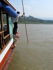
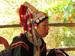
While travelling in the Land of Smiles, we hoped to stay at and experience a traditional and hence “authentic” Akha village. It proved more challenging than we’d anticipated. That’s because although Thai tourism promotes tribal peoples’ colourful costumes and quaint lifestyle, hill tribes are a largely disenfranchised people in crisis. This is true not only for the Akha, but also for other hill tribes such as the Long-necked and White Karen, LaHu, Yao, and Lisu.

What crisis? It appears that the majority of hill tribe people do not qualify for Thai id cards, neither can many own land or possess passports. Therefore, movement within Thailand let alone legally to Burma or other countries is impossible.

IMG_2132
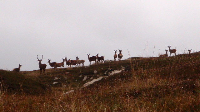
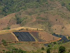
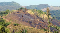
Moreover, the Akha traditionally live in the mountainous regions, preferring to establish villages on the saddle of a ridge. They have an agrarian (swidden) lifestyle and are superb hunters in the jungle-forest habitats.

Such traditions immediately create conflict with the Thai government. One reason is because of the forestry industry: the government’s attempts to control it, create plantations of non-fast-growing pine, and establish some forest preserves mean the Akha (and others who live further down the mountain slopes) have been compelled, quite literally, to move their villages out of newly designated forestry preserves – sometimes at a moment’s notice. Some claim they’ve woken up to find saplings planted in their rice fields in an obvious move to hasten their departure and emphasize their disenfranchised status.

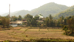
Repeated, forced evictions translate into loss of hope and culture. It produces poverty because as the Akha and others like them are relocated further and further down the mountainside, their traditions and agrarian livelihood directly compete with not only other tribes but also, the lowland Thai people. Due to population pressures, these fully recognized Thai citizens are encroaching further and further up the hillsides. Not only are relocated hill tribes being forced to share their villages with one another (causing increased inter-tribal competition and necessary compromises to further dilute their unique cultures), they must also mix with the Thai.

In one sense, we could nod and say “it’s the way of the world.” But this sort of comment is easily thought and spoken if one is respected, employed, and secure. However, if you are a hill tribe person or community witnessing the unravelling of your culture, loss of identity is bitter and depressing. At best.

Another problem for the hill tribe peoples is degradation and loss of their traditional beliefs and culture due to possibly well-intentioned missionaries. Many Akha speak with sadness if not barely concealed outrage over “the Christians” who build missions (including not only churches but residential or non-residential schools). Just as we have experienced in Canada with our all-too-recent troubled history of enforced residential schools for our First Nations peoples, the Akha and other hill tribes are losing their identity thanks to planned, organized erosion of their culture.

The Akha are animists who have a firm belief in the spirit world. They build and tend spirit houses, spirit gates, and perform many sacred ceremonies wherein the spirit world is woven into their daily lives. In Chiang Rai I saw many beautiful animist spirit houses pushed over and broken. Desecrated. When I asked my Akha guide what had happened, he replied, “It’s the Christians; they do this to us to discourage our belief and try to convert us to their varied faiths. I’ve never understood why there are so many types of Christians: can’t they even get along with one another?”

Good point and the answer is… No.

IMG_2481As merely one example of obvious inequality, it was discouraging to see a Christian mission being erected on the dominant hill of a Karen village outside Chiang Rai. The immense, obviously expensive church was under construction; however, the missionary’s home was complete and stood behind an imposing iron gate.

It is better to give than receive, Christ taught. But when animist hill tribe villagers live in seemingly eternal poverty and the missionaries place a donation box outside their grand edifice, who is eternally giving, and who is receiving more than their due?

With residential schools and missions being built, continual challenges to procuring Thai identity cards, and all the other challenges to Hill Tribe traditions, it seems as though these diverse cultures may be doomed.

But then again, their lives are a journey and so far, they’ve survived myriad setbacks. I hope they continue not only to survive, but to prosper, also.

The power of words

The term “swidden” is defined as “an area cleared for temporary cultivation by cutting and burning the vegetation.”

Now consider how differently we might react to the following two sentences:

  1. The Akha people practice small-scale swidden agriculture to grow food for their families.
  2. The Akha people use slash-and-burn methods to clear land to grow food for their families.

Both have the same meaning—but the choice of one over the other certainly conveys a different message. And if #2 is chosen in a government report about the impact of the Hill Tribe people on the environment, how can it not imply a bias?

This is but one of the problems facing the Akha people of northern Thailand. Even if it were initially unintended, the bias gets picked up by subsequent bureaucrats and the media—and before you know it, it becomes “common wisdom” that deforestation and the subsequent water shortage causing imminent rice crop failures are due to primitive practices of the Hill Tribe peoples.

But could these problems be the result of climate change and long-term precipitation cycles? Or be accelerated by the loss of vast tracts of tropical forests plundered for their hardwoods by “friends” of governments in the region? Such alternatives are harder to explain to an electorate than to set up a scapegoat.

IMG_1789The swidden methods certainly look pretty scary when you see haze in the air or get close to a fire as it blazes through dry bamboo. However, such burning also kills weeds and insect pests, while restoring some nutrients to the soil. Traditionally, the plot would be used, then allowed to go fallow for many years before the cycle repeats.

IMG_1796The official solution to the declining forest resources (and subsequent assumed water problem) has been to move villages (often forcibly) to lower areas, and to declare the uplands as forest reserves. In many places, this has meant reforestation with pine trees—hardly a native species, but suspiciously like a future cash crop.

Like many, I reacted with horror to the burned areas we saw as we explored the hill region. After learning a bit more, and seeing how the people use swidden methods, I’m not so sure it is such a bad thing.

The alternative of farming intensively in the same spot with herbicides, pesticides and fertilizer is unlikely to be a more suitable solution.

Wednesday, February 10, 2010

Jungle lunch

“We’ll hike over there.” Edd pointed to the hills beyond the cleared ridge west of the village of Sae Jai Pattana. We were about to set out on a full-day trek with three Akha villagers. “Wear good shoes.”

Good advice—for us. He and Leeja wore old runners, and Apae wore flip-flops! The trail took us down past fallow and newly-planted rice fields before ascending the ridge and following a newly-laid water pipeline to its source in a spring located higher in the jungle above.

IMG_2051Apae was carrying some cement to seal the small dam at the catchment end of the line, and pushed ahead while Edd and Leeja shared their knowledge of the Akha uses of vegetation as we hiked along the creek.

My first stirs of anxiety about lunch came when Leeja scooped up a little minnow I had noticed in the creek. “Here,” he passed me a bamboo tube, “we can put them in this!”

P2090078Within moments, he had several more minnows—and then a crab, and a shrimp-like creature. When he pulled a frog out from under a muddy rock, I knew lunch would be a challenge.

Edd took the tube to help Leeja, and I joined Katharine to examine the nearby bamboo spirit house built to ensure good water. Apae finished his dam, and as the small reservoir started to fill, we scooped out leaves as all three men collected more lunch ingredients.

IMG_2090We then learned how important bamboo is to the Akha people. Edd split a small length and cut out the dividing parts to make an elegant sluice to provide a clear flow of spring water to clean the catch. Leeja had split a larger diameter piece of bamboo to form a two-section troughs: one side for the items to be cleaned; the other to hold them after cleaning. Meanwhile, Apae made a small fire near a bamboo grove, and filled two bamboo tubes with water, positioning them so the heat would boil the water before the containers dried enough to burn.

IMG_2099It was all very well timed: when the water boiled, Apae added some leaves and the ingredients, while Edd used another bamboo trough to pound chilis, salt and garlic into a paste. Leeja had split a small bamboo length to act as a spit for the frogs (after basting them with some of Edd’s paste).

IMG_2102They’d brought some leaf-wrapped sticky rice for each of us—and some chicken for the second dish in case we were too squeamish. Apae even fashioned some perfect chopsticks.

Leeja chopped a few banana leaves from a nearby tree and laid them out as a mat and serving area. Lunch was ready.

P2090102The ingredients were certainly the challenging part for us, but the preparation was immaculate—and fascinating.

And the food? Tasty enough, but memorable to say the least!

Monday, January 18, 2010

Koh Chang snorkelling

Surprise! We’re picked up by the outfitters not by boat as anticipated but by 2 young Thai on… the dreaded motorbikes. Off I go, doing what I swore I’d never do: riding pillion unprotected, hugging the driver. Eric’s following and yes, we slowly negotiate the rock-strewn road leading from Bang Bao’s Hillside Cottages to the pier where we weave through pedestrians, all of whom are strolling to meet their snorkel or other boat tours. We are safely deposited in front of our spectacular turquoise-and-scarlet painted boat and, in 20 mins we’re off on our four-island snorkelling tour. As promised, only approx 30 people on board: some divers, snorkellers, a “nursery” of tots (cute!), one baby, and some sightseers.

We had purchased our own snorkels & masks at Jomtien Beach but Eric rented flippers for 100 bhat ($3Cdn) for the day. The snorkelling was good but due to last night’s whopping windstorm (according to our host this is not ordinary – he did not sleep a wink all night he said), the visibility was quite poor.

Nonetheless, we had a blast.

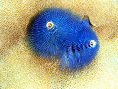
Favourites included coral reef invertebrates known as Christmas Tree worms which came in unbelievable neon blue, gold and scarlet – all had sparkles, too, and were approx 3 cm tall. And definitely, although they damage the reef and an indicator of an unhealthy reef, the big black sea urchins were spectacular. Diving down to look at these spiny critters reveals five bright, silver-white sparkling “eyes” and a tangerine orange and neon purple “mouth.” Stunning colours against the jet black bodies. You don’t want to step on one of these as the spines are apparently very painful. However, they’re easy to avoid while being beautiful to behold.

A surf parrot fish tried to touch us: evidently it was attracted to us for some reason so we had fun observing it for a several minutes worth of interaction. Its fins resemble hummingbirds’ wings with their constant motion, while its body of emerald green with yellow, blue and red highlights was utterly beautiful.

The many corals as well as the giant clams with their amazing coloured “big lips” of purple and other hues, and iridescent fish were all fun to experience. More than anything, the turquoise water was beautifully warm. A languid day of wonderful exercise, where our Thai hosts were friendly and fed us well.

Thumbs up for a great deal.

Thumbs down for any ecotourism perspective: there was no discussion whatsoever of the Mu Kho Chang National Marine Park, nor did staff adhere to the park principles of not feeding the fish or the monkeys which we saw on the rocks en route back to Bang Bao. I was disappointed not to receive any educational component, and not to have others (especially the children) get this much-needed, caring perspective.