Monday, October 25, 2010

Walking in the Devon woods

All of Katharine’s cousins like to hike, so our visits to England always include explorations of their local countryside. Most of our relatives live in central England, but one cousin had moved to Devon since we’d last visited, and we were eager to be introduced to this part of SW England.

PA240332
Eric taking photos from a rock overlooking the valley of the
River Teign along the path to Fingle Bridge from Castle Drogo.
Yet another sunny day threatened to dispel the clichéd view of damp English weather as we drove to nearby Drogo Castle. Now a National Trust site, the castle was completed for food retailing magnate Julius Drewe in 1931. The castle is located on a prominent bluff, and the site includes our destination for the day: a network of walking trails leading along the nearby River Teign.

Not surprisingly on such a fine autumn day, we were not alone as we walked along the edge of the steep valley to descend to Fingle Bridge.

Most walkers stopped at the old stone pub at the bridge, but we continued on along the river for a few kilometres. By the time we returned, the crowds had lessened—but we were only moments from their last call for lunch. The pub lunch and local cider on the outdoor patio was a welcome break before heading back along the river valley trails and the climb back up to the castle.

IMG_0101
These two little girls were dropping twigs off the upstream side, then rushing to
see them float by on the downstream side. Fingle Bridge, near Exeter in Devon.
This area seems so pristine and pastoral, yet a closer look reveals evidence of past industry. The very narrow Fingle bridge is made of rough-hewn stone, and the pub was once a mill; piles of rubble along the trail were probably mine tailings; and old foundations are visible amongst the trees.

IMG_0122
Today the River Teign water looks clean enough to drink, but likely only due to very concerted efforts to restore the local environment.

Is all the effort worthwhile? I suspect the many people we saw enjoying it on this sunny autumn afternoon would not want it any other way.

Saturday, October 23, 2010

Walking along the flinty Norfolk coast

IMG_0026
Carcass of an old boat along
the Blakeney Marsh walking path.
“It’s a beautiful day... I’ll take you up to the Norfolk coast!”

Katharine’s cousin always seems to know just the kind of place to take us in any weather, so we were happy to get our gear together and head north for a day of hiking.

Blakeney is nominally on the North Sea coast, but a large marshland separates it from the salt water. A footpath along the dykes in the marsh leads out to the windy shoreline in low tides, but also forms part of the extensive coastal walking trail system. Although sunny, the wind made us choose to stay inland—and the lure of a pub lunch in nearby Cley Next the Sea became our destination.

IMG_0032
Old windmill at Cley Next the Sea, Norfolk.
IMG_0039Like much of eastern England, the fields in Norfolk contain a lot of flint, a hard stony type of quartz. No doubt farmers have cursed this component of their fields for centuries, but they don’t waste it either. As we walked back to Blakeney we observed flint being used in sidewalk pavers, as walls to define properties—and most dramatically, as part of the exterior cladding on buildings.

It seemed a shame to be so close to the North Sea without actually seeing it, so we drove west to Wells-next-the-Sea.

PA220299A large sand dune shelters a summer holiday park from the sea winds. A short walk over the dune leads to a long sandy beach with dozens of tiny holiday cabins tucked into the steep dune. The harbour here is a staging area for a huge wind farm several kilometres offshore, and signs warn beach strollers about the deep dredged channels and sudden tides.

As the sun neared the horizon, the tide was coming in and the ever-present wind prompted us to head back to the car. As we drove south through rolling hills along the route of an old Roman road, we agreed that a walk along the Norfolk coast should be added to our list of things to do...
IMG_0050
Flying kites on the beach in the late afternoon at Wells-next-the-sea, Norfolk.

Saturday, October 16, 2010

The highlands are actually quite low

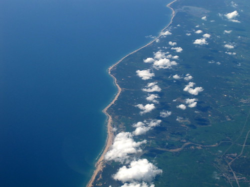
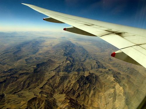
In my mind, the Scottish “highlands” have always conjured up visions of misty crags covered with heather and bracken. We have visited Scotland several times, and have always managed to include some hiking in the hills.

But our stay at a comfortable remote chalet on the NW coast in October was a real eye-opener to the nature of the highlands. The cottage is on the sea, yet within 3 minutes we could be climbing amidst the heather; within 10 minutes we could be out of view of any buildings and roads.

PA090366
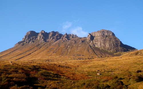
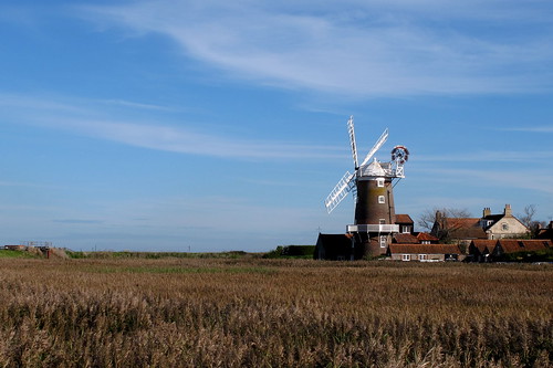
Stac Pollaigh. We climbed this in 1981, but although the weather at the time we passed looked clear, it was only a brief spell of late afternoon sunshine.
In this part of Scotland, trees only grow in sheltered areas, so the treeless “highlands” start just a few metres above the sea level. The hills are not particularly high either: there are only 283 peaks over 914m (a “munro” is a peak of >3,000 feet) within Scotland, and although nearby Stac Pollaidh is an impressive-looking peak, it is “only” 612m high.

IMG_0333
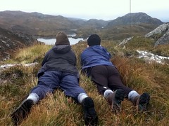
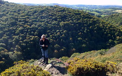
Peering over the ridge to avoid startling stags.
October is rutting season for deer, and the bellows of stags echoed in the hills the night we arrived. We were with my cousin and her husband, and Wayne was keen to take us up into the hills to stalk stags. Just as well he was guiding us: it was clear that “stalking” was necessary, as these animals are very attentive and were easily spooked.

After a couple of hours happily wandering over the hills, we had seen several stags at a distance —young males or ones that were unable to attract a harem of hinds. But then Wayne peered over a ridge and held up his hand to caution us to stop. “Shh... here’s the main herd!”

We got down on our tummies and lifted our heads to look over the rocky ridge. A large stag was looking at us from the opposite ridge—as more than 20 of his hinds were nervously moving further up the hill.

PA130029
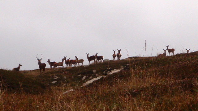
A stag and his hinds.
The life of a stag is not easy. There is only room for one top animal, and there are always contenders for the position lurking around the edges trying to lure hinds away. Eventually, the dominant stag is defeated—or shot. We felt privileged to have the opportunity to see these animals in their environment.

Wednesday, October 6, 2010

Great views from 9.5 kilometres

I can never understand why people ask for window seats and then keep the blinds drawn. With seat back movies, open blinds are less likely to bother neighboring passengers, but our location at the back of the section was perfect for hassle-free viewing as we flew over mostly cloud-free India, Pakistan and Afghanistan.

IMG_1680
Passing over the coast of India’s Andhra Pradesh state.
The view from 12,000m of Pakistan’s Indus River showed a different aspect to the recent flood disaster: the area just beyond the river course is empty desert, so people in the valley would not have been able to just move out of the way.

IMG_1698
The Indus River in flood. Punjab, Pakistan.
Afghanistan was a surprise. Our flight path crossed between Khandahar and Kabul over rugged dry mountains with almost no vegetation, and only the sparsest sign of agriculture in a few of the valleys.

IMG_1717
Irrigated fields and orchards along a watercourse flowing
into Lake Istadeh, Ghazni, Afghanistan.
Roads were quite visible, and some had evident checkpoints along them, but otherwise it seemed incredible that there would be any reason to have our armed forced involved in conflict there.
IMG_1720
The road on the left runs between Kandahar and Kabul:
with our binoculars, we could see a military checkpost along it.
However, the view from above reveals the geopolitical reasons for conflict: access to the Indian Ocean from the north, and the only land passage between the Indian subcontinent and the Middle East has doomed this barren land to conflict for generations.


IMG_1725
Crossroads land: the rugged land below connects oil-rich central Asia
to the Indian Ocean, and the Indian subcontinent to Eurasia.
The eastern shore of the Caspian Sea was clear, but clouds covered most of Georgia and Russia as we flew westward.

IMG_1732
The eastern edge of the Caspian Sea in Kazakhstan
marked the end of clear views for our flight.
We could catch occasional glimpses of neat farmland of Poland and Germany before descending through cloud to land on time at busy Heathrow.

Tuesday, October 5, 2010

A very long day

Our last day on Victoria’s southern coast.
We awoke to a sunny Sunday morning—our last in Victoria, and the start of a long “day” of travel.

Our hosts drove us to Warrnambool to catch the train to arrive in Melbourne at 20:30; then a bus from downtown to the airport. Our flight was to leave at 01:05 Monday morning but we were in the air five minutes early. I’d selected seats at the back of one of the sections to have just two seats in the row; all of the rest of the economy section is configured as 3-4-3. These seats also have a bit more leg room, so we managed to catch a bit of sleep on the 7.5 hr flight to Singapore.

Katharine at the free Internet kiosks at Changi Airport.
Singapore’s Changi Airport is big and modern, with the typical shopping arcade of major airports. Free Internet access helped pass some of the time in our quite welcome 3 hour layover.

Back aboard for the next leg to London Heathrow—and 13 hours in the air as we followed the sun over 12 time zones to arrive at 15:30.

A terrorism threat had no apparent effect on Heathrow arrivals, but the customs clearance wait took almost the hour the signs predicted. Then we were out with our bags and onto a bus to the car hire place. With our GPS installed in the Volvo diesel—and a bit of maneuvering practice in the parking lot—we were soon onto the M25 for the 2 hour drive to Katharine’s cousin’s place.

Finally… into a bed after nearly 44 hours of travel.